+
.com
USD
  • Account
  • Sign Up
  • Sign In
You have no items in your shopping cart.
ABOUT 1OUTLETS
Home Shopping Electronics Car & Vehicle Electronics Marine Electronics Marine GPS Chartplotters Garmin Nvus006r Navionics+ Vision+ U.s. South Microsd
Garmin Nvus006r Navionics+ Vision+ U.s. South Microsd

Garmin Nvus006r Navionics+ Vision+ U.s. South Microsd

Brand

Garmin

( 336 reviews ) See Reviews (1Outlets)

In stock *In Stock - Subject to stock availability at point of fulfilment. In the event whereby the item is out of stock or unable to provide the service, 1Outlets will cancel the order and issue a Full refund in-store credit to you. SKU : ff5f9495c34013c685d38476488c8a52

USD134.13
  • Buy 2 for USD133.53 each and save 0%
  • Buy 10 for USD133.05 each and save 1%
Qty:

**Free Shipping Worldwide available - Shipping time may vary depending on the address.

**Circumstances Reroute - This is a time of great stress and uncertainty. We are actively validating, routing and re-routing orders with our overseas merchants, logistic partners and airlines. Deliveries and supply may expect delays.

**In Stock (Low Inventory Warning) - Subject to stock availability at point of fulfilment. In the event whereby the item is out of stock or unable to provide the service, 1Outlets will cancel the order and issue a Full refund in-store credit to you (See Refunds).

**Report or Request Removal  - Any copyrighted, DMCA, inappropriate, offensive, prohibited, potentially Illegal Listings (Submit doc here).

Details

Garmin: Chart Your Adventure, Conquer the Waves!

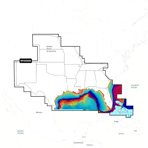
Dive into a world of vibrant detail with the Garmin Navionics+ Vision+ U.S. South microSD. This incredible marine chart unlocks a realm of underwater wonders, navigating you safely to your dream fishing spots or scenic cruising destinations. Experience the thrill of superior mapping and discover the underwater world with clarity like never before, a world of new adventures awaits!

Main Features

  • Detailed Charts: Explore the U.S. South coastline with unparalleled precision, experiencing every contour, rock, and shoal revealed in breathtaking detail.
    • The charts provide incredibly detailed visual representations of underwater terrains, assisting users in route planning and navigation.
  • High-Resolution Satellite Imagery: Gaze upon the beauty of the coastal landscape with crystal-clear satellite imagery, revealing the hidden gems of your destination.
    • This feature will provide an aerial perspective, enhancing situational awareness and helping to identify prominent landmarks.
  • Auto Guidance Technology: Watch as this clever technology quickly charts the safest and most efficient routes, avoiding hazards and shallow waters.
    • This intelligent function helps users navigate safely, ensuring they have an easier and safer trip.
  • SonarChart Shading: Visualize bottom contours in high definition, helping to locate fish-holding structures and uncover the secrets of the deep.
    • This feature helps improve the understanding of underwater terrains and assists in enhancing the fishing experience.
  • Community Edits: Share your knowledge and benefit from the wisdom of fellow boaters, getting up-to-date and reliable chart information.
    • User-generated content helps keep information accurate and relevant, ensuring the best possible navigation experience.

Benefits

  • Enhanced Safety: Navigate with confidence, knowing you have the most up-to-date charting information at your fingertips.
    • Stay informed of potential dangers and avoid accidents, enjoying peace of mind during your journeys.
  • Improved Navigation: Chart your course with pinpoint accuracy, allowing you to reach your destination faster and more efficiently.
    • Make the most of your time on the water, easily find your way through complex waterways.
  • Superior Awareness: See the world beneath the waves come alive with detailed and visually stunning maps.
    • Become more aware of your surroundings and make informed decisions on the water.
  • Greater Fishing Success: Discover hidden fishing spots and maximize your chances of a successful catch.
    • Enhance your fishing experience with knowledge of bottom structures and fish-holding locations.
  • Unforgettable Adventures: Explore new waters, making memories and discovering the joy of boating and cruising!
    • Discover beautiful landscapes, finding treasures and sharing adventures with others.

Unique Selling Points / Competitive Advantages

  • Unmatched Detail: Garmin offers unparalleled chart detail, empowering the ability to see things others can’t.
    • The level of precision is unrivaled, giving users a superior understanding of their environment.
  • Seamless Integration: Effortlessly integrate with existing Garmin chartplotters, creating an intuitive and easy-to-use system.
    • This system simplifies setup and use for those already familiar with the Garmin ecosystem.
  • Dynamic Data: Benefit from constantly updated chart information, ensuring you always have the latest data available.
    • The charts are regularly updated, keeping the system current and precise.
  • Advanced Features: Auto Guidance and SonarChart Shading provide industry-leading technology, enhancing safety and performance.
    • These features help make the product stand out from competitors by providing unique functions.
  • Trusted Brand: Count on Garmin's reputation for quality, dependability, and innovation in the marine industry.
    • You are assured of the reliability and performance that come with the Garmin brand.

Usage Scenarios

  • Recreational Boating: Effortlessly explore new coastal waters and discover hidden coves for memorable experiences.
    • Perfect for weekend getaways and family outings on the water.
  • Fishing Expeditions: Locate prime fishing locations and identify underwater structures, increasing your chance of a prized catch.
    • Enhance your fishing and navigate to the best spots on the water.
  • Cruising Adventures: Plan scenic routes and navigate to distant destinations with confidence and ease.
    • Enjoy comfortable and safe journeys.
  • Water Sports: Improve awareness of underwater hazards, enjoying water sports with added safety and enjoyment.
    • Enhance the overall safety of watersports activities.
  • Coastal Exploration: Discover the beauty and wonder of the U.S. South coastline, enjoying its treasures.
    • Appreciate the diverse beauty of the coastal areas.

Customer Reviews / Testimonials

  • "This chart card has transformed my fishing trips! The SonarChart Shading helps me find the perfect spots. It's fantastic!" - Michael from Miami, Florida (USA), 2023
    • Michael praised the card's ability to locate prime fishing spots.
  • "The detail on these charts is incredible, I've seen things I didn't know existed. It's improved my boating in ways I never imagined." - Isabelle from Nice, France, 2022
    • Isabelle mentioned how the charts have improved her overall boating experience.
  • "I always feel safe and confident, knowing I have such reliable mapping. The Auto Guidance feature is a lifesaver!" - Carlos from Buenos Aires, Argentina, 2023
    • Carlos highlighted the feeling of safety and confidence the product provides.
  • "It's easy to use and it is always updating. A great product overall!" - Kenji from Tokyo, Japan, 2022
    • Kenji appreciated the ease of use and the fact that the charts always have the latest information.
  • “This card has saved my family countless times. I highly recommend to any boater.” - Samuel, Sydney, Australia, 2024
    • Samuel recommended to any boaters due to safety.

Frequently Asked Questions

  • Q: Is the chart easy to install?
    • A: Absolutely! Simply insert the microSD card into your compatible Garmin chartplotter and follow the simple on-screen instructions.
  • Q: Does it cover all of the U.S. South?
    • A: Yes, it provides comprehensive coverage of the U.S. South coastal regions, offering detailed mapping information.
  • Q: How often are the charts updated?
    • A: The charts are regularly updated, providing users with the latest data and ensuring accuracy.
  • Q: Can I use it on multiple devices?
    • A: The microSD card is designed for use on a single compatible device, ensuring optimal performance and data integrity.
  • Q: Will it help me find fishing spots?
    • A: Yes! With features like SonarChart Shading, you can visualize bottom contours and identify promising fishing locations.

BUY NOW

Garmin empowers you to venture into the unknown! Navigate with confidence, and make your maritime dreams a reality. Set sail on a journey of discovery. Garmin is your gateway to exploration!

(Beta: User Generated 2024.0007)
Specification
Category: Electronics > Car & Vehicle Electronics > Marine Electronics > Marine GPS Chartplotters
Brand:

Garmin

Weight: 0.01kgs
Terms & Warning