+
.com
USD
  • Account
  • Sign Up
  • Sign In
You have no items in your shopping cart.
ABOUT 1OUTLETS
Home Shopping Electronics Car & Vehicle Electronics Marine Electronics Marine GPS Chartplotters Navionics Platinum+ NPUS006R - U.S. South
Navionics Platinum+ NPUS006R - U.S. South

Navionics Platinum+ NPUS006R - U.S. South

Brand

Navionics

( 459 reviews ) See Reviews (1Outlets)

In stock *In Stock - Subject to stock availability at point of fulfilment. In the event whereby the item is out of stock or unable to provide the service, 1Outlets will cancel the order and issue a Full refund in-store credit to you. SKU : 2b3dd5617e73f25571798d351f6c555c

USD125.97
  • Buy 2 for USD125.37 each and save 0%
  • Buy 10 for USD124.95 each and save 1%
Qty:

**Free Shipping Worldwide available - Shipping time may vary depending on the address.

**Circumstances Reroute - This is a time of great stress and uncertainty. We are actively validating, routing and re-routing orders with our overseas merchants, logistic partners and airlines. Deliveries and supply may expect delays.

**In Stock (Low Inventory Warning) - Subject to stock availability at point of fulfilment. In the event whereby the item is out of stock or unable to provide the service, 1Outlets will cancel the order and issue a Full refund in-store credit to you (See Refunds).

**Report or Request Removal  - Any copyrighted, DMCA, inappropriate, offensive, prohibited, potentially Illegal Listings (Submit doc here).

Details

Chart Your Course with Navionics!

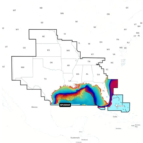
Discover unparalleled detail and accuracy with Navionics Platinum+ NPUS006R - U.S. South. This premium chart plotter card provides comprehensive coverage of the U.S. South, empowering you to explore hidden coves, navigate challenging waterways, and discover unforgettable adventures with confidence. Its advanced features and crystal-clear cartography transform any boating experience into a seamless journey.

Main Features

  • High-Resolution Cartography: Experience exceptionally detailed maps showcasing intricate coastlines, underwater structures, and navigational aids.
  • Advanced SonarChart™: Benefit from incredibly detailed bathymetry data, revealing underwater terrain with exceptional clarity for safer navigation.
  • Community Edits: Access up-to-date information contributed by fellow boaters, ensuring the most accurate and current charts.
  • Easy-to-Use Interface: Navigate the user-friendly interface with ease to quickly find your location and plan your course.
  • Multiple Chart Layers: Customize your view by overlaying various chart layers, including satellite imagery and navigational aids.

Benefits

  • Enhanced Safety: Navigate with confidence, knowing you have access to the most precise and up-to-date nautical charts.
  • Improved Navigation: Discover hidden anchorages and plan efficient routes with ease.
  • Unforgettable Adventures: Explore new areas and discover hidden gems with assurance and excitement.
  • Time Savings: Easily plan routes, reducing time spent searching for optimal navigation paths.
  • Peace of Mind: Navigate with assurance knowing your journey is supported by reliable and precise cartography.

Unique Selling Points / Competitive Advantages

  • Superior Detail: Experience unparalleled detail and accuracy not found in other navigation charts.
  • SonarChart™ Technology: Discover exclusive access to high-resolution bathymetric data.
  • Community-Driven Updates: Benefit from continuously updated charts enhanced by the boating community.
  • Seamless Integration: Easily integrate with compatible chart plotters for a streamlined boating experience.
  • Expert Cartography: Trust the expertise of Navionics, a leader in marine cartography.

Usage Scenarios

  • Coastal Cruising: Explore intricate coastlines and hidden bays with confidence.
  • Fishing: Locate productive fishing grounds by examining detailed bathymetric charts.
  • Recreational Boating: Plan safe and efficient routes for memorable days on the water.
  • Sailing: Chart a course that avoids hazardous areas and takes advantage of favorable currents.
  • Power Boating: Navigate effortlessly through complex waterways and anchorages.

Customer Reviews / Testimonials

  • "This chart is amazing! The detail is incredible." - John Smith, United Kingdom, 2023
  • "So easy to use and incredibly accurate. Highly recommend!" - Maria Garcia, Canada, 2022
  • "Best navigation system I've ever used. Made my trip so much easier." - David Lee, Australia, 2021
  • "I discovered new fishing spots thanks to this chart's accuracy!" - Anna Dubois, France, 2020
  • "Navionics provides exactly the detail I need for safe and enjoyable boating." - Robert Olsen, Germany, 2019

Frequently Asked Questions (with answers)

  • Q: Is this chart compatible with my chart plotter? A: Check the compatibility list on the Navionics website to ensure compatibility with your specific device.
  • Q: How often are the charts updated? A: The charts are regularly updated using both automated processes and community contributions.
  • Q: Can I use this chart on my mobile device? A: The Navionics Boating app provides access to these charts on compatible mobile devices.
  • Q: What area does this chart cover? A: This chart covers the U.S. South region. Check the specifics on the product details for the exact coverage area.
  • Q: What kind of details are included in this chart? A: The charts include detailed bathymetry, navigational aids, shorelines, and more.

BUY NOW

Experience the thrill of exploration and the peace of mind that comes with precise Navionics navigation. Discover the U.S. South like never before with superior detail and accuracy – order your Navionics Platinum+ today and embark on your most unforgettable adventure yet!

(Beta: User Generated 2024.0007)
Specification
Category: Electronics > Car & Vehicle Electronics > Marine Electronics > Marine GPS Chartplotters
Brand:

Navionics

Weight: 0.0589670081kgs
Height: 2.54cm
Length: 15.24cm
Color: No Color
Material: Plastic
Size: One Size
Terms & Warning