+
.com
USD
  • Account
  • Sign Up
  • Sign In
You have no items in your shopping cart.
ABOUT 1OUTLETS
Home Shopping Office Products Office & School Supplies Education & Crafts South America Wall Map GeoPolitical Edition by Swiftmaps (18x22 Laminated)
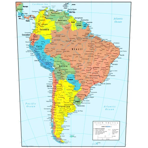
South America Wall Map GeoPolitical Edition by Swiftmaps (18x22 Laminated)

South America Wall Map GeoPolitical Edition by Swiftmaps (18x22 Laminated)

( 395 reviews ) See Reviews (1Outlets)

In stock *In Stock - Subject to stock availability at point of fulfilment. In the event whereby the item is out of stock or unable to provide the service, 1Outlets will cancel the order and issue a Full refund in-store credit to you. SKU : 3b15f5972af69ca2751b7f4721416714

USD10.28
  • Buy 2 for USD9.69 each and save 6%
  • Buy 10 for USD9.27 each and save 11%
Qty:

**Free Shipping Worldwide available - Shipping time may vary depending on the address.

**Circumstances Reroute - This is a time of great stress and uncertainty. We are actively validating, routing and re-routing orders with our overseas merchants, logistic partners and airlines. Deliveries and supply may expect delays.

**In Stock (Low Inventory Warning) - Subject to stock availability at point of fulfilment. In the event whereby the item is out of stock or unable to provide the service, 1Outlets will cancel the order and issue a Full refund in-store credit to you (See Refunds).

**Report or Request Removal  - Any copyrighted, DMCA, inappropriate, offensive, prohibited, potentially Illegal Listings (Submit doc here).

Details

Swiftmaps South America Adventure Awaits!

Bold South America Wall Map GeoPolitical Edition by Swiftmaps (18x22 Laminated)

This vibrant and detailed South America wall map is an essential learning tool and stunning display for any room. The geopolitical edition provides clear visibility of boundaries and countries, perfect for students, teachers, and geography enthusiasts alike. The laminated surface ensures durability and easy cleaning. Engage in exploration and deepen your understanding of the world with this educational and captivating South American map.

Main Features

  • High-definition graphics: Offers intricate details of each country and region, allowing for a comprehensive view.
  • Detailed geopolitical information: Accurately shows country boundaries, capitals, and significant landmarks for a clear understanding of the geographical layout.
  • Durable laminated finish: Protects the map from spills, marks, and wear, ensuring longevity.
  • Large scale format: Enables clear visibility for both close and distant observations.
  • Colorful and appealing design: Captivates young learners and fosters engagement in studying geography.

Benefits

  • Improved understanding of geography: Provides a tangible reference to enhance geographical awareness.
  • Visual learning support: Visually engaging map boosts understanding and retention of information.
  • Durable display: The laminated surface protects the map and its details.
  • Versatile educational tool: Supports various educational needs.
  • Inspiring exploration: Provides motivation to learn and explore the vastness of South America.

Unique Selling Points / Competitive Advantages

  • Geopolitical focus: Detailed information on boundaries and political regions sets this map apart.
  • Laminated durability: Provides increased longevity and protection from damage, making it a valuable investment.
  • Large scale for easy viewing: Enhances visibility for classrooms and homes.
  • Child-friendly design: Appeals to younger audiences, encouraging engagement and learning.
  • Exceptional value: Offers detailed features and substantial impact in a budget-friendly approach.

Usage Scenarios

  • Classroom learning: A fantastic tool for teachers to display and use in lessons.
  • Educational resource for homes: A visual aid to reinforce learning at home.
  • Study room or office: Adds depth and interest to any space, stimulating learning.
  • Geography projects: A perfect reference for students to illustrate their geography studies.
  • Travel planning: Helps to visualize destinations and learn about South American countries before visiting.

Customer Reviews / Testimonials

  • Maria Rodriguez (Chile, 2023): "My child loves this map! It's colorful and easy to understand, helping her learn about South America."
  • Ahmed Ali (Egypt, 2024): "This South American map is fantastic. The clarity of the geopolitical details is truly impressive."
  • Sophia Lee (Canada, 2023): "The South America wall map is a lovely addition to my classroom, making it easy for my students to visualize their studies. Highly recommend!"
  • David Chen (China, 2024): "Great for visual aids. Easy to see, and South American details were very accurate."
  • Isabella Rodriguez (Brazil, 2023): "The South American detail made this map a must-have for my personal library."

Frequently Asked Questions

  • Q: Is the map laminated? A: Yes, the South America wall map is laminated for added durability and protection.

  • Q: What type of information does this map provide? A: This geopolitical map features detailed country borders, capitals, and significant locations, providing an accurate depiction of South America's geographical layout.

  • Q: Is this map suitable for children? A: Yes, the colorful and engaging design, along with clear geopolitical information, make it an ideal educational resource for children.

  • Q: How can this South American map be used in a classroom? A: Use it as a visual reference, for discussions, study sessions or to aid students in creating projects.

  • Q: What is the map's scale? A: The South American map is designed on a large scale for optimal visibility.

BUY NOW

Discover the wonders of South America with the Swiftmaps South America Wall Map. Experience the excitement of exploration through detailed visualization. Get your geopolitical map today for enhanced learning and vivid displays.

(Beta: User Generated 2024.0007)
Specification
Category: Office Products > Office & School Supplies > Education & Crafts
Weight: 0.049895160656kgs
Terms & Warning